







 配送


GARMIN aera 660 GPS 航空用 3D立體地圖 導航儀 觸控瑩幕 接地障礙危險警告功能(太平洋區)的詳細資訊
本商品需客製預訂 Pacific 太平洋區(交期4~5週)
詳請來電洽詢 零九一零三五五三一八
GARMIN aera 660 GPS 航空用 3D立體地圖 導航儀7觸控瑩幕 接地障礙危險警告功能
攜帶型GPS包裝中的高級功能
堅固的專用攜帶型GPS導航儀,內置GPS / GLONASS接收器和5英寸陽光下可讀屏幕
直觀,簡單的觸摸屏操作和單電源按鈕使顯示屏變得輕鬆自如
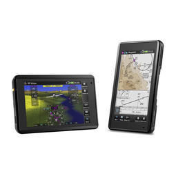
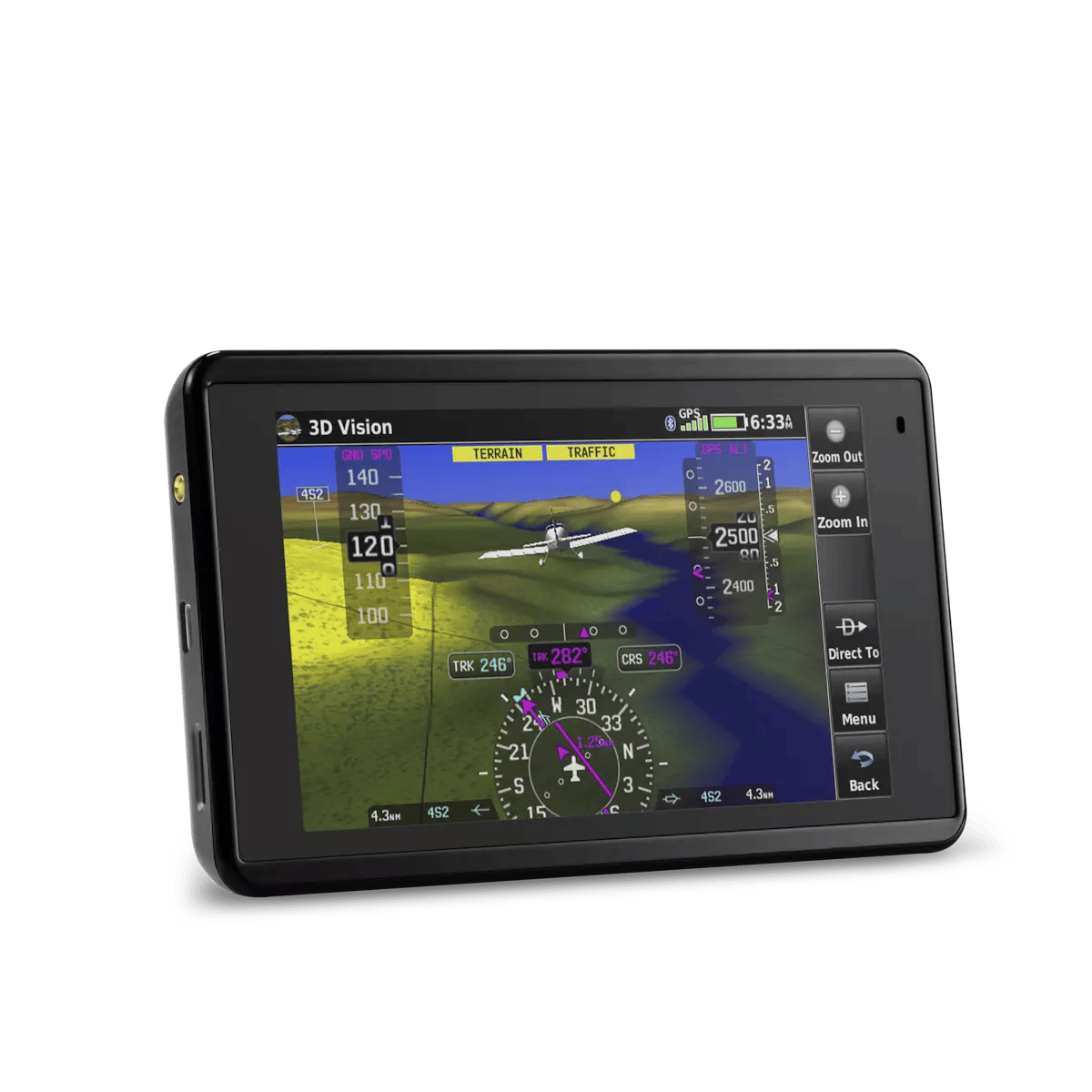
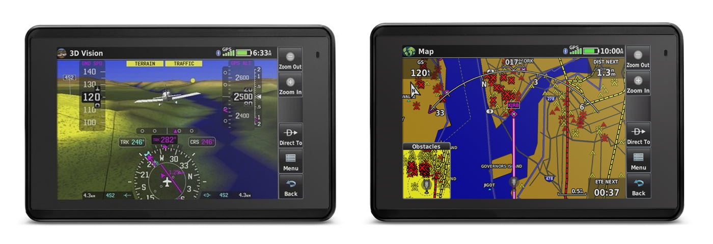
3D Vision透視圖顯示地形,障礙物,機場環境,可選交通,最近的機場等等
通過Connext®流無線座艙連接ADS-B weather1和來自兼容設備的高級流量
通過Wi-Fi®數據庫下載和經濟實惠的Garmin導航數據庫,切斷線纜和數據庫價格
意識在你手中
aera 660航空便攜式將最新的Garmin技術放在您的手掌中,它繼承了我們創造創新導航儀的傳統,可以回到手持式航空GPS的起點。雖然aera 660重量輕,結構緊湊,可裝在任何飛行包中,但它的功能也很齊全。作為專用導航儀,它可以快速可靠地獲取GPS和GLONASS衛星星座,並將先進的導航工具與豐富的交互式動態繪製航空地圖結合起來。並將其全部顯示在明亮的陽光下可讀的5英寸對角電容式觸摸屏上。
任何使用Garmin GTN™觸摸屏GPS / NAV / COMM,G5000®集成駕駛艙或Garmin Pilot™應用程序的用戶都可以使用aera 660上的圖標,並且直觀的界面可讓您快速平移地圖屏幕,捏縮放等等。同時,頂部的電源按鈕可進行快速設置,包括縱向或橫向,音量和亮度。 aera 660配備了卡入式動力支架,便於您的飛機和家庭之間的運輸。
完整的飛行映射
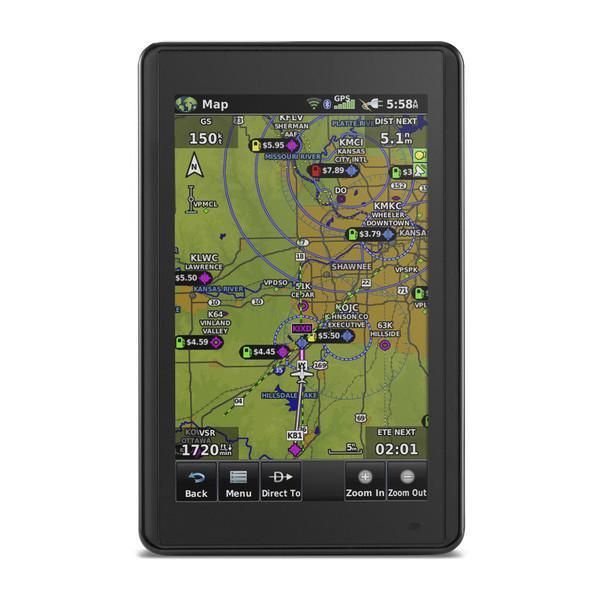
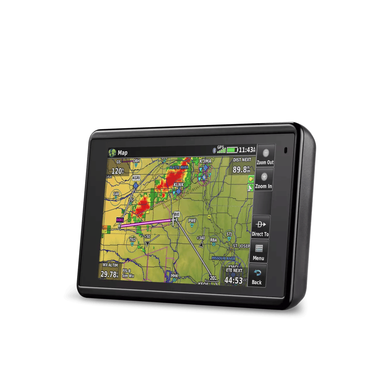
aera 660航空便攜式預裝了詳細的飛行地圖,地形和障礙警報,美國,歐洲和加拿大的SafeTaxi®海圖和AOPA機場目錄或可選的AC-U-KWIK全球機場目錄,將豐富的資源置於您的指尖 - 包括當地燃油價格(僅限美國)。圖形地形頁面提供了您下方地形的頭頂和垂直剖面視圖。切換到IFR地圖模式以在高或低航線上顯示和導航,並使用觸摸屏地圖光標引用MEA(最小航路高度)和交叉點之間的距離。 aera 660甚至提供垂直導航(VNAV)指導以簡化航路轉換。
您將會留意特殊的空域活動,並提供超過650個降落傘降落區詳情(僅限美國),並獲得一鍵式空域信息。 Garmin Smart Airspace™指南可方便地突出顯示當前海拔最近的空域,並不重視不相關的空域,以便快速識別相對於您周圍空域的位置。當然,aera 660包括我們的直接和最近機場的導航。
與您的面板連接
使用可選的電源/數據線(另售),aera 660可與Garmin航空電子設備連接,從GTN 750/650和GNS 530W / 430W導航儀接受飛行計劃,並將頻率上傳到GTR 200的待機位置Comm收音機,GTR 225 Comm收音機或GNC 255 NAV / COMM收音機。它還為您的Garmin NAV / COMM無線電提供查找最近頻率所需的GPS位置信號源。
ADS-B無導線
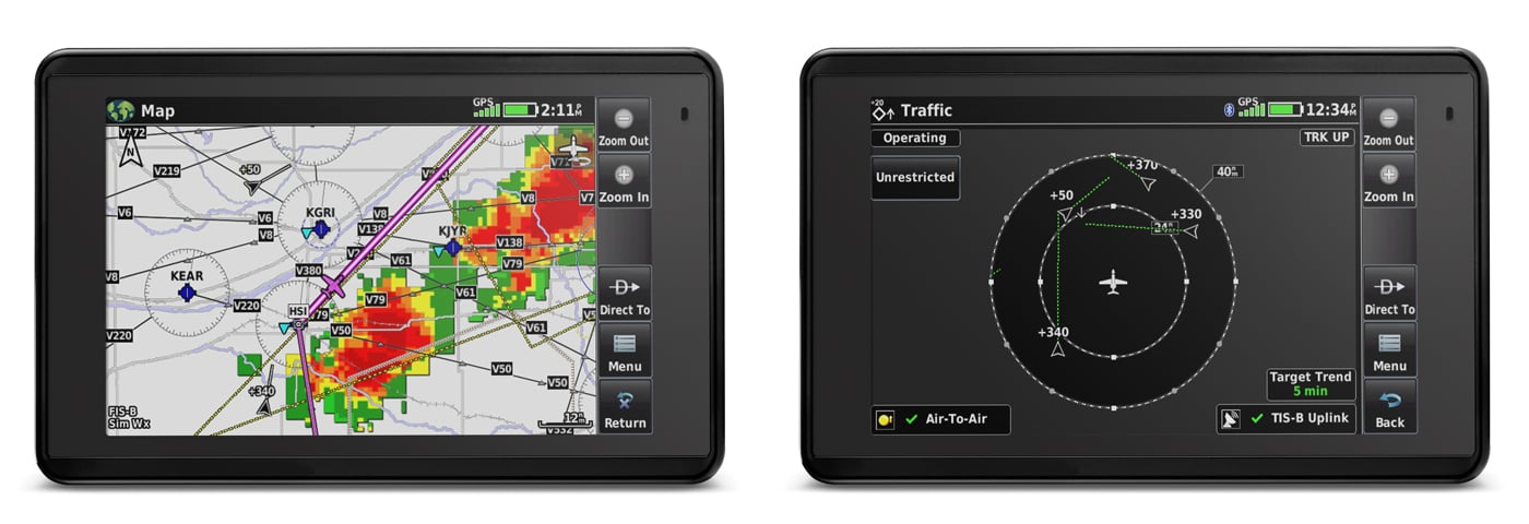
使用通過Garmin Connext技術的藍牙®連接,aera 660可輕鬆與兼容設備進行交互,以減少駕駛艙內的混亂,並改善您的飛行體驗。使用GarminGDL®39便攜式ADS-B接收機或GTX 345一體化ADS-B應答機,您可以訪問和顯示ADS-B免費預訂天氣¹和高級交通警報,包括TargetTrendTM相對運動跟踪和TerminalTrafficTM,您意識到繁忙的候機樓空域可能存在衝突。它甚至可以通過無線控制GarminVIRB®動作攝像頭來啟動和停止錄製和拍攝照片。
獲取3D透視
革命性的3D視覺技術為您提供了從GPS / GLONASS和機載地形數據庫中導出的周圍地形的虛擬三維透視圖。在觸摸屏上滑動手指以旋轉視圖,並在相對靠近飛機的位置顯示陸地和水景,障礙物,跑道和機場路標。當通過飛行流210,GDL 39系列便攜式ADS-B數據鏈路或GTX 345 ADS-B轉發器將aera 660連接到姿態源時,Garmin SVX合成視覺和姿態命令條會自動添加到您的顯示器上。
此外,憑藉其前瞻性的地形避讓能力,aera 660可預先預測可能存在塔樓或障礙物的位置,並用琥珀色或紅色覆蓋物遮蓋景觀以指示這些區域。此外,獲得幫助,避免與Garmin WireAware™線纜罷工避免技術發生衝突,該技術以圖形方式覆蓋移動地圖頁面上橫跨河流和峽谷的危險障礙物傳輸(HOT)線路,適用於美國以及美國的部分地區加拿大和墨西哥。觸摸導線以顯示MSL和AGL高度,並根據您與危險的距離查看顏色編碼障礙警報。包含所有電力線的可選完整數據庫也可用。
與Garmin保持同步
使用aera 660,您可以切斷電源線 - 以及數據庫價格。您可以通過Wi-Fi更新數據庫而不是連接到計算機,並且可以通過一個單一的,經濟實惠的年度訂閱來保持當前的數據,包括您需要的所有數據庫,包括Garmin導航數據庫(僅限美國,加拿大,墨西哥版本)。
一體化功能
aera 660滿足I級或II級電子飛行包的作用,大大減少了依靠駕駛艙紙質海圖的需求。美國地理參考的VFR分段和IFR航路圖預先加載,以顯示您的飛機位置直接覆蓋在相關的圖表上,還可選擇歐洲和加拿大的VFR和IFR圖表和機場圖表。
在IFR地圖模式下,aera 660可以顯示維多利亞航空公司,噴氣航線,航程和更多,類似於傳統的航路圖。此外,喜歡Jeppesen圖表和圖表的飛行員可以使用內置的ChartView功能,該功能使用Jeppesen廣泛的庫來提供全球地理參考圖表功能。歐洲用戶可獲得歐洲VFR地圖增強功能,以查看更多視覺參考點,包括邊界,湖泊,道路,草地,公園等。
aera 660家庭碼頭
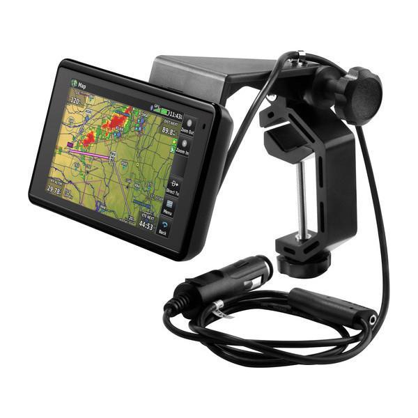
設計用於安全地將您的aera 660放在您的家中,辦公室或 駕駛室中用於桌面使用,這款堅固的金屬支架與您的便攜式導航儀附帶的USB和電源適配器電纜配合使用 - 可讓您在放置時充電aera的觸摸屏,因此您可以使用它設置飛行計劃,查看機場信息,並輕鬆便捷地執行其他關鍵的預檢計劃任務。
在一個階級本身
憑藉其豐富的功能列表,aera 660將面板安裝的航空電子設備的許多功能與價值包裝的專用封裝相結合。這是一個專門的合作夥伴,可以立即開箱即用。
機體和性能
GPS尺寸:5.5“×3.4”H×0.8“D(14.1×8.7×2.1厘米)
顯示尺寸WxH:4.35“W×2.61”H(11.1×6.6厘米); 5.08“diag(12.9cm)
顯示分辨率,WxH:480 x 800;肖像和風景取向
顯示類型:帶白色背光的觸摸屏WVGA彩色TFT
重量:帶電池的8.64盎司(245克); 7.23盎司(205克)不含電池
電池:可拆卸,可充電鋰離子電池
電池壽命:在大多數白天條件下(80%的背光)和駕駛艙內的無線連接,例如長達4小時。 GTX 345;在典型的夜間條件下(5%背光)和無線連接可達6小時。
SBAS / WAAS / GLONASS接收器:具有WAAS位置精度的高靈敏度
電壓範圍:10-35
IFR或VFR:VFR
交通信息服務(TIS)警報兼容:是的
接受數據卡:是(microSD™卡)
標準配備
aera 660
帶電源線的座架
電池
AC適配器
USB電纜
快速入門手冊和相關文檔
Complete Flight Mapping
The aera 660 aviation portable comes preloaded with detailed flight mapping, terrain and obstacles alerting, U.S., European and Canadian SafeTaxi® charts and AOPA Airport Directory or optional AC-U-KWIK global airport directory to put a wealth of resources right at your fingertips — including local fuel prices (U.S. only). The graphical Terrain page offers both overhead and vertical profile views of the topography beneath you. Switch to IFR map mode to display and navigate on high or low enroute airways, and use your touchscreen map cursor to reference MEAs (Minimum Enroute Altitudes) and distances between intersections. The aera 660 even provides vertical navigation (VNAV) guidance to simplify en-route transitions.
You’ll stay aware of special airspace activity with more than 650 parachute drop zone details (U.S. only) and get 1-touch airspace information. Garmin Smart Airspace™ guidance conveniently highlights the airspace nearest your current altitude and de-emphasizes non-pertinent airspace so you can quickly identify your location relative to the airspace around you. And, of course, the aera 660 includes our signature direct-to and nearest-airport navigation.
Connect With Your Panel
With an optional power/data cable (sold separately), the aera 660 connects with your Garmin avionics to accept flight plans from your GTN 750/650 and GNS 530W/430W navigators, as well as upload frequencies to the standby position of your GTR 200 Comm radio, GTR 225 Comm radio or GNC 255 NAV/COMM radio. It also provides your Garmin NAV/COMM radios with the GPS position source required to look up nearest frequencies.
ADS-B Without Wires
Using Bluetooth® connectivity via Garmin Connext technology, the aera 660 easily interfaces with compatible devices to cut the clutter in your cockpit and improve your flying experience. With a Garmin GDL® 39 portable ADS-B receiver or GTX 345 all-in-one ADS-B transponder, you can access and display ADS-B subscription-free weather¹ and advanced traffic alerts, including TargetTrendTM relative motion tracking and TerminalTrafficTM, so you’re aware of potential conflicts in busy terminal airspace. It even allows wireless control of Garmin VIRB® action cameras to start and stop recording and capture photos.
Get 3D Perspective
Revolutionary 3D Vision technology gives you a virtual 3-D behind-the-aircraft perspective view of surrounding terrain derived from GPS/GLONASS and the onboard terrain database. Slide your finger across the touchscreen to rotate the view and show land and water features, obstacles, runways and airport signposts in relative proximity to the aircraft. And when you connect aera 660 to an attitude source through a Flight Stream 210, a GDL 39 series portable ADS-B data link or a GTX 345 ADS-B transponder, Garmin SVX synthetic vision and attitude command bars are automatically added to your display.
Plus, with its forward-looking terrain avoidance capability, the aera 660 predicts in advance where towers or obstacles may exist and shades the landscape with amber or red overlays to indicate those areas. Also, get help flying clear of conflicts with Garmin WireAware™ wire-strike avoidance technology, which graphically overlays Hazardous Obstacle Transmission (HOT) that span rivers and canyons right on the moving map page, for the U.S. as well as in some locations in both Canada and Mexico. Touch the wire to display both MSL and AGL heights, and see color-coded obstacle alerting depending on your distance to the hazard. An optional full database that includes all power is also available.
Stay Up to Date With Garmin
With the aera 660, you can cut the cord — and your database prices. You can update databases via Wi-Fi instead of connecting to a computer, and stay current throughout the year with a single, affordable annual subscription that includes all the databases you need, including the Garmin Navigation Database (U.S., Canada, Mexico-version only).
All-in-one Functionality
The aera 660 fulfills the role of either a Class I or Class II electronic flight bag, greatly reducing the need to rely on paper charts in the cockpit. U.S. geo-referenced VFR sectional and IFR enroute charts come preloaded to show your aircraft’s position overlaid directly on the relevant chart, and optional European and Canadian VFR and IFR charts and airport diagrams are also available.
When in IFR map mode, the aera 660 can display victor airways, jet routes, leg distance and more, similar to traditional enroute charts. Plus, pilots who prefer Jeppesen charts and diagrams can use built-in ChartView capability, which uses Jeppesen’s extensive library to provide global geo-referenced charting capabilities. European users receive European VFR Map enhancements to see even more visual reference points, including borders, lakes, roads, grasslands, parks and more.
aera 660 Home Dock
Designed to securely hold your aera 660 for desktop use in your home, office or pilot lounge, this sturdy metal mounting stand works with the USB and power adapter cables provided with your portable navigator – allowing you to to keep your unit charged, while positioning the aera’s touchscreen so you can use it to set up flight plans, review airport information, and perform other key preflight planning tasks, comfortably and conveniently.
In a Class by Itself
With its long list of features, the aera 660 combines many of the capabilities of panel-mounted avionics with a value-packed, purpose-built package. It’s a dedicated partner that’s ready to fly, right out of the box.
Physical & Performance
Physical dimensions: 5.5”W x 3.4”H x .8”D (14.1 x 8.7x 2.1 cm)
Display size, WxH: 4.35\"W x 2.61\"H (11.1 x 6.6 cm); 5.08\" diag (12.9cm)
Display resolution, WxH: 480 x 800; portrait and landscape orientation
Display type: touchscreen WVGA color TFT with white backlight
Weight: 8.64 ounces (245 g) with battery; 7.23 ounces (205 g) without battery
Battery: removable, rechargeable lithium-ion
Battery life: Up to 4 hours during most daytime conditions, (80% backlight) and wireless connectivity in the cockpit, e.g. GTX 345; up to 6 hours during typical nighttime conditions, (5% backlight) and without wireless connectivity.
SBAS/WAAS/GLONASS receiver: high-sensitivity with WAAS position accuracy
Voltage range: 10-35
IFR or VFR: VFR
Traffic Information Services (TIS) alerts compatible: yes
Accepts data cards: yes (microSD™ cards)
商品備註・物品狀況:全新・最新關注時間:2023-08-07





暢銷商品排行榜





查看此商品的人也看了以下商品
-
 我的商店庫存: 307含稅5891元
-
 我的商店庫存: 419含稅15857元
-
 我的商店庫存: 315含稅21413元
-
 我的商店庫存: 314含稅22192元
-
 我的商店庫存: 363含稅7369元
附近賣場的商品


顧客評論
推薦度 4.5分
目前有 101則評論。